
Trace a Fort Cavazos Street
Begin by normalizing the address exactly as it appears in the record. Fort Cavazos, Fort Hood, Camp Hood, ZIP 76544, Killeen, and a Bell or Coryell County label can all appear in sources tied to the same broad area. Bell CAD recommends entering a whole address first, then simplifying to the street name and number and dropping a suffix if needed. That practical change can uncover a parcel whose older source uses a different directional prefix or street ending. Keep the raw spelling, the normalized spelling, the document date, and the county in your notes.
For a civilian parcel, a street-directory trail should move from the address to a parcel account and then to the record that has the legal weight for the question. The CAD account supplies a property or geographic ID, situs address, legal description, and deed-history lead. A county clerk instrument establishes the recorded party role and document date. A voter status result, when used by the person entitled to use it, is status-specific and never proves present occupancy. On-post building numbers and installation roads follow a separate federal path and may not appear in a civilian parcel search.
- Run the address through USPS ZIP Lookup and preserve the city, state, and ZIP exactly as returned.
- Search the right appraisal district by address, beginning with Bell CAD eSearch on the Bell side or Coryell CAD on the Coryell side.
- Record the parcel or geographic ID, legal description, subdivision, block, lot, and source date before using another system.
- Use the county clerk index to search the grantor, grantee, instrument number, subdivision, document type, or recorded date tied to that parcel.
- Use My Voter through VoteTexas only for the appropriate individual status or polling check, and treat any result as date-bound registration information.
- For a dated household clue, consult cataloged directories and maps, then verify it against a clerk, archive, or other dated record.
Note: A street search is strongest when each result is labeled as a parcel, instrument, map layer, or historical directory clue rather than a current household list.
Fort Cavazos Street Name Keys
Street names need their own search vocabulary here. The USPS Postal Bulletin records the Fort Hood-to-Fort Cavazos postal change for ZIP 76544 in 2023, while current Army material can still use Fort Hood. A deed, map, directory, or permit may therefore use a legacy place name without being wrong. Search the requested name and the older aliases, but keep the document's original wording in the citation. Replacing an older label silently can hide the very term needed to find a scan or index entry.
Street changes can matter as much as installation aliases. Killeen's street-name rules recognize duplicate names, misspellings, directional coherence, suffix changes, honorifics, and neighborhood history as reasons a name can change. Compare the current address with a plat, subdivision name, block and lot, historic directory spelling, and annexation context. A legal description can remain useful even when a delivery label changes. Conversely, a replat can alter lot and block references, so both the newer and earlier description may need searching.
Fort Cavazos Street Directory Fields
Bell CAD is the main street-directory entry point for civilian property on the Bell County side. Its public help page supports owner and address searching, property IDs, and an advanced business or DBA field. The address search can be narrowed from a whole address to a street or number pattern. Results may be downloaded as CSV or sent by email, although the map has known limits for personal, mineral, mobile-home, and unmapped property. The output is appraisal data, not conclusive title or evidence of residency.
| Bell CAD field | Input type | Required | Street-search use |
|---|---|---|---|
| Owner name | Text | No | Try first and last names with spelling variations. |
| Address or street | Text | No | Start whole, then remove a suffix or simplify to the number and street. |
| Property ID or Geographic ID | Text | No | Use the exact identifier when a prior record supplies it. |
| Advanced business or DBA | Text | No | Use only when a public entity name is the known parcel clue. |
The safe field inventory from a Bell property card includes property and geographic IDs, property type, situs, map ID, subdivision, block, lot, owner and mailing fields, values, exemptions, acreage, roll-history years, and deed-history references. The observed sample showed roll history from 2016 through 2025. These fields connect a street to a record trail, but a mailing address can belong to an owner who does not occupy the property.
Fort Cavazos Parcel to Deed Trail
A parcel card is a navigation tool. Once Bell CAD returns an account, write down its legal description and any deed date, type, grantor, grantee, volume, page, or number shown in the history. Then use the Bell County official-record search, where the search term can cover grantor or grantee, subdivision, document type, and document number. The portal also offers recorded-date ranges and an Index Only or Index & Full Text OCR scope. Images can require registration or cart access.
Call each name by the role printed in the instrument. A grantor transfers an interest; a grantee receives one. A trustee, lender, estate, or entity may appear in the same record without being an occupant. This distinction keeps the Fort Cavazos street directory focused on source-backed facts. It also prevents a common error: treating an old deed-history row as both current title and current residence. County-recorded instruments are stronger title evidence than an appraisal roll, but the date and document type still control what they establish.
- Parcel
- A tax and mapping unit used by an appraisal district to organize a property account.
- Situs address
- The physical location used for the property record, which can differ from an owner mailing address.
- Plat
- A recorded map that identifies a subdivision, street, lot, block, or replat relationship.
- Criss-cross directory
- A directory arranged by street and address rather than only by name, when a collection has that format.
Coryell Fort Cavazos Street Route
The Fort Cavazos footprint reaches Coryell County, so a Bell-only result is never a complete street-directory conclusion. Coryell CAD eSearch accepts owner, street, property or geographic ID, tax year, subdivision or neighborhood, and several appraisal-review fields. Its help material says to search streets without a prefix, suffix, or unit. GIS mapping and ownership or value information are separate functions there, so use a map as parcel context and the account card for the appraisal record.
For a recorded document on that side, the Coryell hosted eDoc search offers a date range, partial full name, instrument number, and records-per-page controls. The accessible research did not establish a firm online cutoff or a universal image rule. When the portal does not answer the question, the Coryell County Clerk is the fallback custodian for real-property, civil, probate, guardianship, brand, and vital-record routing. Name the county in each request so a Fort Cavazos label is not mistaken for a single civil jurisdiction.
Here is the assigned capture of the Coryell eDoc public-record search, showing the document-search route rather than a person-level result.
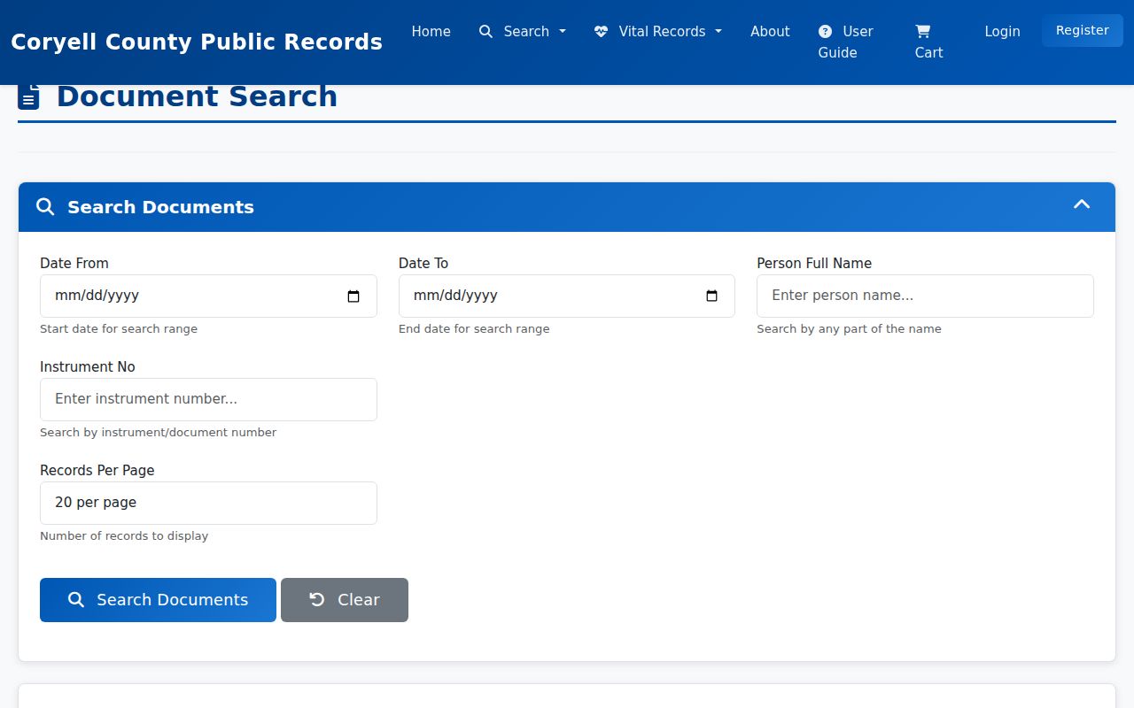
The form is most useful after an address search supplies a party role, date, subdivision, or instrument number to test in the Coryell index.
Fort Cavazos Street Record Sources
Records keyed to an address do not all mean the same thing. This Fort Cavazos street directory coverage separates property, geography, recorded title, local building history, and dated historical context. Use the first source that fits the question, then follow its identifier into the next custodian rather than trying to make one portal answer every question.
| Address record | Local keeper | What it can show | Access route |
|---|---|---|---|
| Parcel or account card | Bell or Coryell CAD | Situs, account IDs, legal description, values, and owner-of-record lead | Current public property portals |
| Parcel map and layers | CAD GIS or Killeen GIS | Parcel shape, roads, lots, and annexation context | Dynamic public map, not an occupancy record |
| Recorded instrument | Bell or Coryell County Clerk | Party role, instrument, recording date, and legal-description trail | Online index, clerk copy, or older books and microfilm |
| Permit or inspection | Killeen Development Services | Permit number, type, issue or final inspection, and certificate lead | MGO workflow or focused public-information request |
| Historical map or directory | UT, TSLAC, LOC, library, or archive | Date-bound place, building, and household clues | Catalog, reading room, microfilm, or digitized item |
For municipal building records, Killeen Building Inspections describes an electronic permit and inspection workflow. Older material may need a request. A focused request for a final permit, certificate of occupancy, date range, and parcel or address is more likely to reach an existing record than a broad request for material about an occupant.
Fort Cavazos Street Maps by Date
GIS is most useful when it stays visual and bounded. Search a parcel or street, inspect the roads and parcel shapes around it, then query each parcel separately in the proper CAD. Killeen GIS adds city layers and street context. Killeen's annexation-history layer includes a Year_ display field, and the research identified values such as 1883, 1920, 1948, and 1949. That can explain why a historic address later appears in a city service system.
Bell CAD's observed property-card design also adds a useful numbers layer: property and geographic IDs, acreage and dimensions, land and improvement values, tax jurisdictions, and roll-history rows. These numbers identify a record and a date range. They do not identify a household. When a street lies near a military boundary, rights-of-way, large tract, or apartment complex, map proximity should not become a claim that two people are neighbors or that either occupies the parcel.
Note: A map point can confirm a location layer, but title, delivery, city jurisdiction, and federal installation status require separate records.
Older Fort Cavazos Street Clues
When a modern parcel page has no useful earlier layer, dated directories and maps can put an address in context. The UT Center for American History directory index accepts a location, directory type, and optional year range. Its Killeen metadata lists R.L. Polk & Co. volumes for 1965, 1970, 1972, 1974, 1976 through 1978, 1980 through 1981, and December 2003. The catalog is evidence that a volume exists, not proof of a particular entry. The historical collections are discussed in more depth on the Fort Cavazos city directory page.
Here is the assigned capture of the UT directory index, where a researcher can filter a collection by location, type, and year.
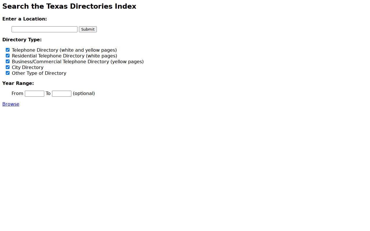
Pair a cataloged volume with a county deed, a map sheet, or another dated record before drawing a conclusion about an address or household.
Fort Cavazos Federal Street Records
Fort Cavazos is a federal installation, not an incorporated Texas city. Some addresses use building numbers, installation road names, or post-city conventions that a civilian CAD system does not represent. The Army public phonebook and installation offices are the right routing source for an official facility question. Do not force a federal facility address into Killeen, Bell CAD, or Coryell CAD just because a nearby civilian street appears in one of those systems.
The installation crosses Bell and Coryell Counties, while a Census CDP and a postal label describe other kinds of geography. For an on-post address, first identify whether the question concerns a public facility, a federal administrative record, or civilian land outside the gate. Army FOIA or Privacy Act routing applies to federal records, while Texas county and city routes apply to their own records. Operational, personnel, and private information can be restricted even when a road name is public.
Fort Cavazos Street Privacy Limits
A Fort Cavazos street directory cannot establish a current resident, list every household member, or turn a mailing address into an occupancy claim. A CAD owner-of-record field, a ZIP result, a voter status record, and a historic directory are all time-bound records with different limits. Protected voter addresses, motor-vehicle information, military household details, sealed court material, and restricted federal records must remain protected. When the source is uncertain, link to the custodian and preserve the date rather than assembling more personal detail.
Lawful use. Fort Cavazos address records are for personal, lawful research and record verification. Texas Penal Code Chapter 42 addresses harassment and stalking; never use address clues to stalk, harass, intimidate, or harm anyone.
Bell and Coryell records can also be incomplete online because older books and indexes may sit on microfilm or at a repository. A no-result should lead to a jurisdiction, spelling, instrument, date, or archive check, not an unsupported conclusion about a person or place.